According to the National Highway Traffic Safety Administration, 2015 saw a 7.2 percent increase in traffic fatalities – the highest single-year increase since 1966.
The state of Texas is consistently the greatest contributor to these numbers: in 2015, Texas accounted for 10.2 percent of traffic fatalities in the nation. Years of data tell us that 62 percent of Texas traffic fatalities occur on its sprawling network of highways and interstates – around 80,000 miles in total.
Where along this massive network are motor vehicle occupants at higher risk of a deadly accident? We consulted with data visualization firm 1Point21 Interactive to find the deadliest stretches of highway in Texas.
Through our analysis, we found that from 2013-2015, nearly 12 percent of all traffic fatalities in Texas occurred on 78 sections of highway totaling 464 miles – just over half of one percent (0.58 percent!) of Texas highways. You can view an interactive version of the map by clicking here.
Insights
- The 78 deadly stretches we identified accounted for 1,297 fatal crashes and 1,473 fatalities during the three year study period.
- The deadliest stretch of highway in Texas is a 1.49-mile section of of I-69. Located in Edinburg, a modest-sized south Texas city, 12 traffic fatalities occurred here over the three-year period – roughly 8.05 fatalities-per-mile.
- 11 of the 78 deadliest stretches of highway were found along I-35, the most of any highway. Only I-35, I-10 (with 10), and I-20 (with 7) had more than three.
- Stretches of I-410 in San Antonio and I-45 in Houston had the most overall fatalities, each accounting for 50.
The 78 Deadliest Stretches of Highway in Texas
*Ranked by fatalities per mile. Mile point is the center of each stretch and acts as an identifier between each one (especially on highways represented by more than one stretch.)
The Deadliest Stretch: I-69C in Edinburg
The deadliest stretch of highway in Texas is a 1.5-mile strip of I-69 in Edinburg. 12 traffic fatalities give the small section a whopping 8.05 fatalities-per-mile. How does a city with a rough population of 87,000 have such a deadly stretch of highway?
Although Edinburg may seem like a small town, it is important to note that it is part of the McAllen-Edinburg-Mission metropolitan area, which has an estimated population of 842,000 as of 2015. Considering that high population, it’s likely that this stretch of I-69 receives an uncharacteristically high volume of traffic daily.
However, the real answer may lie in the highway layout before this stretch of highway. Interestingly, this section of I-69 is unconnected to the “proper” Interstate 69. Named I-69C (for “Central”), the highway is a small portion of SH-281 that has been co-opted into the Interstate system.
The 1.5-mile stretch in question is located on I-69C north of SH-281 Business, a short business route that connects back to I-69C from the south. This can be an important contributor to fatalities, due to:
- Merging and lane-changing incidents – in 2015, there were 35,533 crashes in Texas as a result of improper lane-changing.
- Poorly adjusting to speed limit – SH-281 Business has posted speed limits of 35mph to 55mph, while I-69C has a speed limit of 75mph. The sudden change in speed can be incredibly dangerous to drivers, especially if they’re going under the limit. In 2015, there were nearly 61% more fatal crashes in Texas as a result of going under the limit rather than speeding.
Further research is required to truly find a cause for so many fatalities in this tiny stretch, but it is certainly a cause for concern.
Distribution of Deadly Highway Stretches
Although many Texas cities are represented in our list, it’s largely dominated by Austin, Dallas, Houston, and San Antonio – the four largest cities in Texas, and four of the top 10 most populated cities in the United States.
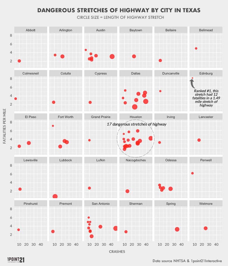
A Closer Look: Houston
- Deadly Stretches of Highway: 17
- Total Length: 100.5 miles
- Total Fatalities: 345
- Fatal Crashes: 316

17 deadly stretches were found in Houston, the most of any city in Texas. The fourth largest city in America, Houston has had a recent population boom unlike most cities – from 2014 to 2015, it had the single largest population growth of any city in the nation.
This population growth has also led to some of the worst traffic congestion in the country. According to the Texas A&M Transportation Institute, commuters in Houston lost 61 hours to traffic in 2014. Additionally, Houston is home to 44 of the top 100 congested roads in the state, with 10 of those in the top 20.
The relationship between congestion and traffic accidents has been hotly debated – some studies contend that there is a correlation, while others still don’t believe it to be the case. This comprehensive list seems to indicate that there may be some correlation between population growth, congestion, and frequency of traffic fatalities.
A Closer Look: San Antonio
- Deadly Stretches of Highway: 10
- Total Length: 50.6 miles
- Total Fatalities: 176
- Fatal Crashes: 153
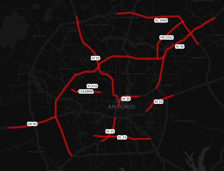
San Antonio had 176 fatalities spread across 10 deadly stretches of highway. A large concentration of these fatalities took place in a 14-mile stretch of I-410, a major highway that loops around the city.
A simple explanation for so many fatalities on this one expanse of highway is that, because it’s a major highway, the quantity of traffic remains high. Indeed, San Antonio remains a highly congested area as well, with drivers spending, on average, 44 hours on the road in 2014.
Additionally, I-410 serves as a main highway for some of the more densely traveled landmarks in the city.
- JBSA – A military facility directly off the highway that’s operated by both the US Army and the Air Force
- Texas A&M San Antonio – an independent state university that’s part of the large Texas A&M University System
- San Antonio International Airport – a large international hub located on the northernmost part of the I-410 loop.
With one highway serving so many major city locations within close vicinity, it’s not surprising to have a high frequency of traffic incidents and fatalities.
A Closer Look: Dallas
- Deadly Stretches of Highway: 9
- Total Length: 77.9 miles
- Total Fatalities: 249
- Fatal Crashes: 223(Ft Worth: 4 stretches with 90 fatalities, Arlington: 2 stretches with 38 fatalities)
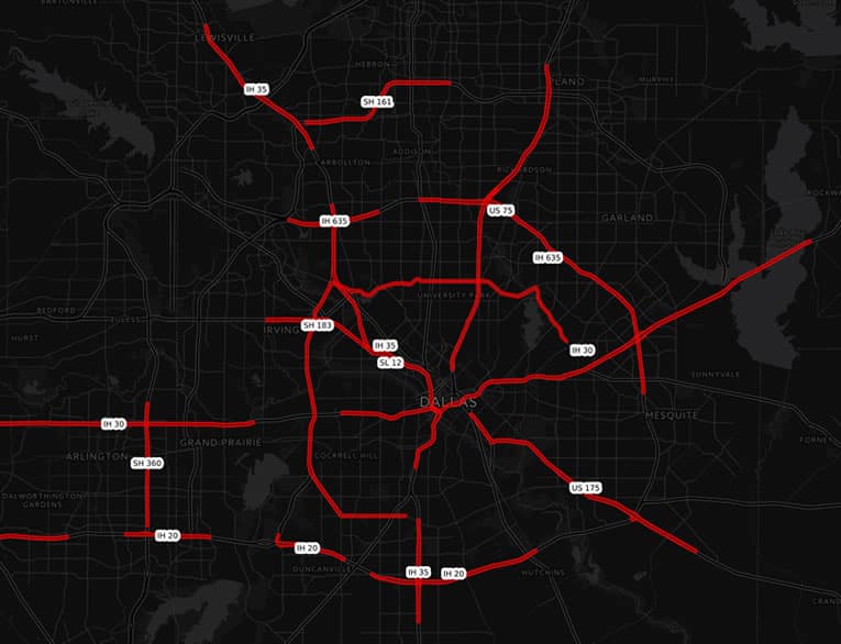
Dallas has nine dangerous stretches of highway, accounting for 249 fatalities. Two of those are the longest stretches of dangerous highway on the list: a nearly 17-mile-long stretch of SL-12 and a 15.5-mile stretch of I-30.
Additionally, this only looks at Dallas proper. Extrapolating our data to include the over-arching Dallas-Fort Worth-Arlington metropolitan area gives us more alarming numbers: 15 dangerous stretches of highway and 377 fatalities, higher than Houston’s fatalities
A Closer Look: Austin
- Deadly Stretches of Highway: 7
- Total Length: 41.4 miles
- Total Fatalities: 127
- Fatal Crashes: 113
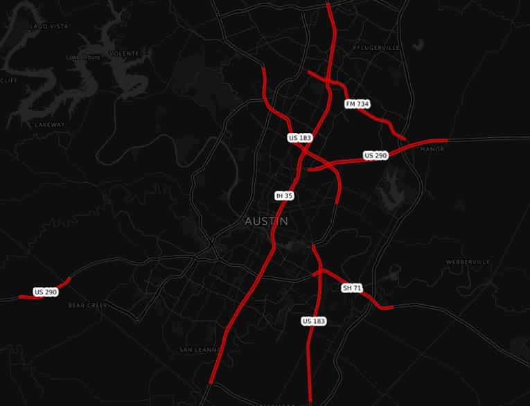
Compared to the other major cities in Texas, Austin has a fairly conservative seven deadly stretches of highway. However, it has a large amount of fatalities somewhat evenly spread across large stretches of highway. In fact, calculating fatalities-per-mile of the entire city nets a total of 3.07 fatalities-per-mile – higher than the 3.03 fatalities-per-mile of San Antonio.
Additionally, congestion is a huge issue in Austin as well, with commuters losing 52 hours to traffic in 2014. Considering the high number of fatalities-per-mile, Austin may be another candidate that shows a relationship between congestion, traffic, and traffic fatalities.
A Closer Look: Odessa
- Deadly Stretches of Highway: 5
- Total Length: 29.6 miles
- Total Fatalities: 82
- Fatal Crashes: 74
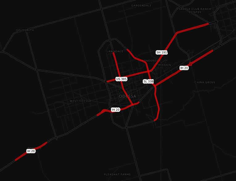
Odessa seems like an unlikely hotbed for traffic fatalities, but with 82 fatalities distributed across five highway sections, it has its share of danger.
Indeed, Odessa may seem like a small town, but according to the Census, from 2014 to 2015, it was one of the 20 fastest growing cities in the nation. A good reason for that may be the oil boom in the early 2010’s due to rising oil prices. Odessa is located in the Permian Basin, a region in the Southwest United States mainly known for oil and energy production.
Odessa, along with Midland, is known as one of the highest producers of oil and gasoline in the nation. However, with a surge in business comes a surge in traffic – and compounded dangers on the road. Some stretches of I-20 and SH-191 are often rife with semi-trucks and oil tankers, often driving in narrow, poorly-maintained roads. Coincidentally, I-20 and SH-191 saw the most fatalities in Odessa.
Another major contributor to fatalities in this area seems to be a resistance to wearing seat belts. In one five-month stretch, nearly 56 percent of traffic fatalities in Midland County were found to be not wearing seatbelts. While we don’t know why these West Texas cities have such a high incidence of not wearing seat belts, the evidence is clear: wearing seat belts saves lives.
Methodology and Data Sources:
Our geospatial analysis took into account every Texas traffic fatality reported to the National Highway Traffic Safety Administration (NHTSA), using data from the Fatality Analysis Reporting System (FARS) from years 2013, 2014 and 2015. The list of 78 deadly stretches includes all stretches with more than 10 fatalities during the study period and are ranked by fatalities per mile.
Why are the stretches different lengths? Our analysis found fatality clusters using a 2.5 mile radius, therefore, the stretches run until they encounter a section of highway of more than 2.5 miles without a fatality. A more detailed methodology is available upon request.